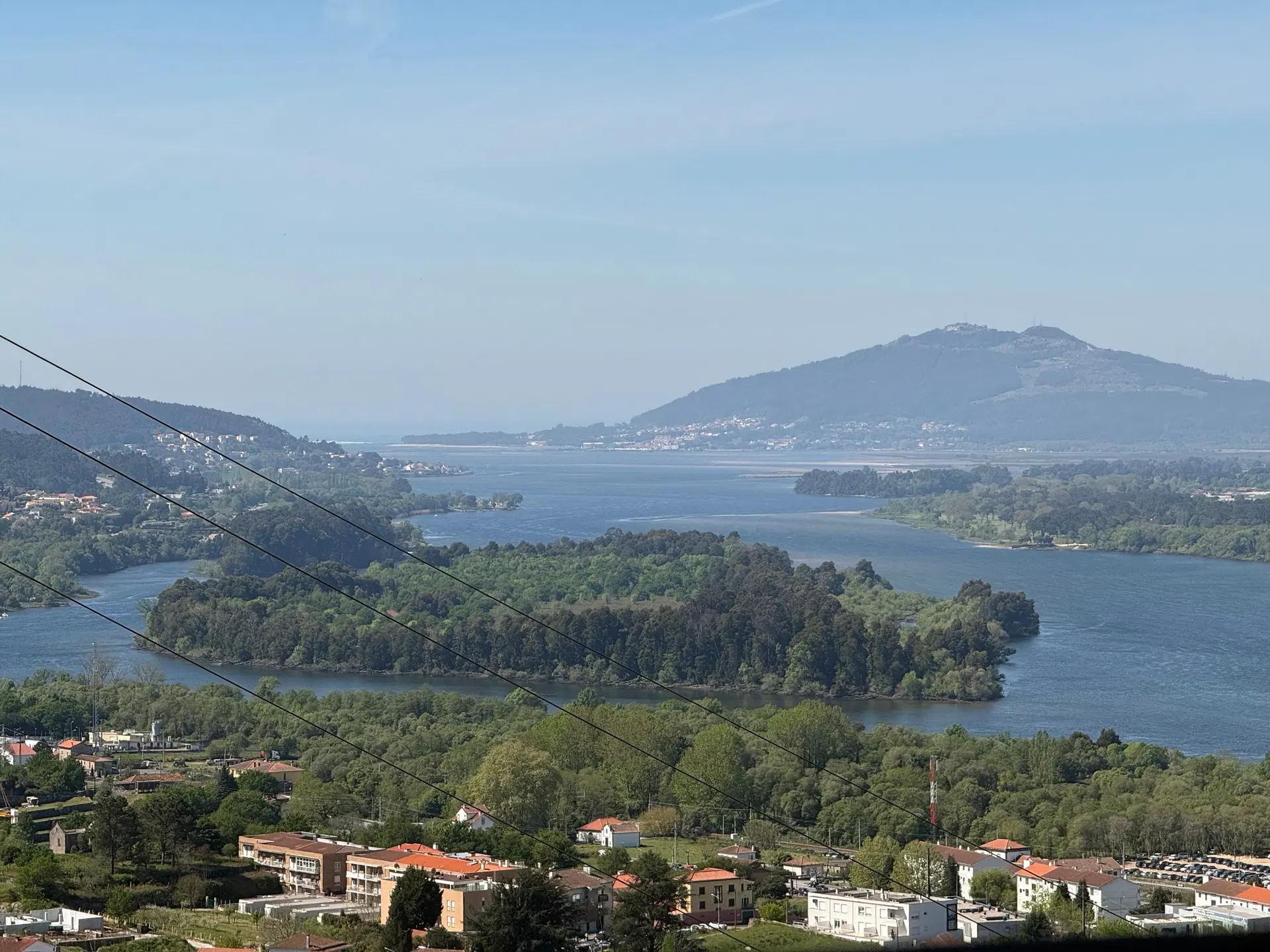
Monte Santa Tecla — Santa Trega in Galician, and on every road sign — is the hill you see from Caminha and Moledo across the river: 341 metres straight above the mouth of the Minho, in A Guarda, Galicia. On top sit one of the largest hillforts of the Iron Age castro culture, an archaeological museum more than a century old, a medieval chapel and the best view on the border: the river meeting the Atlantic, the whole Portuguese bank, the Minho valley running inland.
From the house it is about 30 minutes to A Guarda over the Friendship Bridge and along the Galician bank, plus a few minutes of hill road to the summit. Half a day is enough; with lunch in the harbour it is the easiest Galician day out from Gondar.
The Santa Trega hillfort
The citania of Santa Trega covers roughly 20 hectares of hillside. According to the A Guarda council, the settlement's origins are documented from the 4th century BC and it peaked around the turn of the era, with an estimated 3,000 to 5,000 inhabitants. Excavations began in 1912 under the Sociedad Pro Monte, and the site was declared a National Historic-Artistic Monument in 1931 — today a Bien de Interés Cultural, Spain's top heritage listing.
What you walk through is a stone village: dozens of round and oval houses, narrow lanes, the defensive wall, the excavated Mergelina quarter and reconstructed houses you can step inside, which make sense of how people lived here two thousand years ago. Petroglyphs scattered over the hill predate the hillfort itself.
The MASAT museum
The Museo Arqueolóxico de Santa Trega (MASAT) was founded in 1917 and moved in 1953 to the building on the summit, designed by the architect Antonio Palacios. It holds what came out of the digs: pottery, Roman coins, glass, torcs and the "cabezón do Trega", the carved stone head that became the site's emblem. It is small and worth half an hour — it gives context to what you have just walked over.
It opens Tuesday to Sunday, with hours that shift through the year: later into the evening in summer, closing at 5 pm (Spanish time) in winter. Closed on Mondays, all of January and the first half of February. Check the current month's hours on the A Guarda council's tourism portal before you set off.
Driving up: the fee and the hours
The hill road climbs to the car park at Pico de San Francisco, beside the chapel, the museum and the summit restaurants. Access on foot is free. By car you pay a municipal fee at the entrance barrier. According to the A Guarda council's tourism portal, the current rates are:
| Vehicle | Fee |
|---|---|
| Car (driver included) | 3 € |
| Adult passenger | 1.50 € |
| Reduced rate (ages 6–14, youth card, large families) | 1 € |
| Motorcycle | 2 € |
| Motorhome | 4 € |
The fee includes entry to MASAT. Barrier opening hours are not published in a stable form and vary by season: ask the Concello de A Guarda (aguarda.es or turismoaguarda.es) before driving up, especially outside summer.
The chapel, the cross and the viewpoints
The hill has two summits. On Pico de San Francisco (341 m) stand the chapel of Santa Trega, documented since the 12th century and rebuilt in the 16th and 17th, a 16th-century stone cross and the view over the river mouth. From Pico do Facho (328 m) you look the other way: the O Rosal valley, the town of A Guarda and its fishing harbour. Between the two run a modern Way of the Cross by the sculptor Vicent Mengual and several viewpoints along the road.
If you want to stretch your legs, the PR-G 122 "Camiños do Trega" is a network of seven waymarked paths totalling about 7 km across the hillsides.
How long, and when
- Minimum: an hour and a half — drive up, hillfort, chapel viewpoint.
- Unhurried: three hours — add the museum, the guided tour and Pico do Facho.
- Best time: late afternoon, when the sun drops over the Atlantic and the light rakes across the hillfort stones. Mornings are cooler for walking the ruins with children; on days when fog sits on the estuary, postpone.
Remember that Galicia runs an hour ahead of Portugal: museum and barrier hours are Spanish time.
Getting there from the house
Two good roads, and one crossing you should not rely on.
- Over the Friendship Bridge (shortest): 14 minutes to Goián, then the Galician bank of the Minho (PO-552 or CG-4.2) to A Guarda — about 30 minutes in total according to the usual route planners. The climb adds a few minutes.
- Via Valença and Tui: 20 minutes to Tui over the international bridge, then the PO-552 downstream, about 30 minutes more. Choose this loop if you want to add Tui to the day.
- Caminha and the ferry: the Caminha–A Guarda car ferry has been out of service for several years; Caminha's council has announced plans to restore it with a new vessel, but check the current status with the Câmara Municipal de Caminha. Licensed water taxis run between the two piers for passengers and bicycles only.
What to combine it with
A Guarda deserves the descent: a working fishing town with a proper harbour, the Museo do Mar and lobster as its flag — the Festa da Langosta e da Cociña Mariñeira takes over the harbour, usually in early July (each year's dates on the council's tourism portal), and is a festival of tourist interest in Galicia. Outside the festival, the harbour is still where you go for a fish and seafood lunch.
- Half a day: Santa Trega + lunch in A Guarda, back over the Friendship Bridge.
- Full day: Tui in the morning, Santa Trega in the afternoon, or the reverse to catch sunset on the hill.
- With a swim: back in Portugal, Lenta beach and the Minho's river beaches are on the way home.
What the hill is not: a place to spend hours in the heat without shade. Do it early or late, and keep the middle of the day for a table in the harbour.
Common questions
Are Santa Tecla and Santa Trega the same place?
Yes. Santa Trega is the official Galician name of the hill and the hillfort; Santa Tecla is the Spanish and Portuguese form. Road signs, the museum and the Xunta's heritage records say Santa Trega; English-language searches mostly use Santa Tecla. Either way it is the same 341-metre hill above A Guarda.
Do you pay to go up Monte Santa Tecla?
On foot, no. By car there is a municipal fee at the barrier on the hill road: according to the A Guarda council's tourism portal, 3 € per car plus 1.50 € per adult passenger (1 € reduced rate), with the MASAT museum included. Fees and barrier opening hours can change, so check with the Concello de A Guarda before you go.
How long does the visit take?
Between an hour and a half and three hours: the drive up, the hillfort (the free guided tour lasts about 45 minutes), the museum and the viewpoints on the summit. With lunch in A Guarda's harbour it fills a morning or an afternoon from the house.
Can I take the ferry from Caminha?
Don't count on it. The Caminha–A Guarda car ferry has been out of service for several years; Caminha's council has announced plans to restore the link with a new vessel, so check the current status with the Câmara Municipal de Caminha. Licensed water taxis carry passengers and bicycles only — no cars. From the house the road is the safe option: about 30 minutes to A Guarda over the Friendship Bridge.
Is it a good outing with children?
Yes. The hillfort is a stone village with reconstructed round houses you can step inside, the guided tour is short and there is a picnic area on the hill. Bring water, hats and a layer: the summit is exposed to sun and wind, and the hillfort walls are not fenced.